‧ Waterproof ‧ Tear-Resistant ‧ Topographic MapIn the spring of 1996 wildfire roared through the Buffalo Creek area. Soon after a group of dedicated mountain bikers, working the US Forest Service, sta
‧ Waterproof ‧ Tear-Resistant ‧ Topographic MapSeeking the best combination of detailed maps and value for your trip to the Yellowstone and Grand Teton area, then get our bundle pack. It includes both
‧ Waterproof ‧ Tear-Resistant ‧ Topographic MapSeeking the best combination of detailed maps and value for your trip to South Dakota's Black Hills, then get our bundle pack. It includes both Black Hil
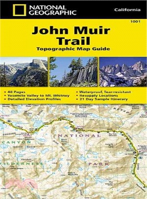
‧ Waterproof ‧Tear-Resistant ‧Topographic Map GuideNational Geographic's Map Guide of the John Muir Trail is an indispensable tool for navigating one of the most famous trails in the United States. Ex
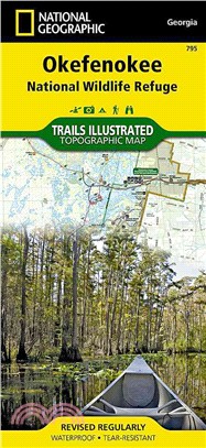
‧ Waterproof ‧ Tear-Resistant ‧ Topographic MapNational Geographic's Trails Illustrated map of Okefenokee National Wildlife Refuge is a two-sided, waterproof map designed to meet the needs of outdoor
• Waterproof • Tear-Resistant • Travel MapColorado uses Game Management Units (GMUs) to describe hunting boundaries. National Geographic has created Map Pack bundles to aid hunters with
‧ Waterproof ‧ Tear-Resistant ‧ Topographic MapNational Geographic's Trails Illustrated map of Big Sur / Ventana Wilderness - Los Padres National Forest is a two-sided, waterproof map designed to meet
• Waterproof • Tear-Resistant • Topographic MapThe Washington South Topographic Map Guide follows the Pacific Crest Trail (PCT) as it travels through a landscape dotted with lakes, pere
• Waterproof • Tear-Resistant • Topographic MapCompletely revised and expanded our Colorado National Monument Trails Illustrated map details the high use recreation areas throughout Colorado's Grand V
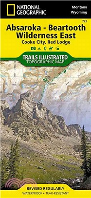
• Waterproof • Tear-Resistant • Topographic MapNational Geographic's Trails Illustrated map of Absaroka-Beartooth Wilderness East delivers unmatched detail and valuable information to a
• Waterproof • Tear-Resistant • Topographic MapNational Geographic's Trails Illustrated map of Absaroka-Beartooth Wilderness West is a two-sided, waterproof, topographic trail map designed to meet the
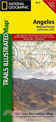
‧ Waterproof ‧ Tear-Resistant ‧ Topographic MapNational Geographic's Trails Illustrated map of Angeles National Forest is a two-sided, waterproof map designed to meet the needs of outdoor enthusiasts
• Waterproof • Tear-Resistant • Topographic Map GuideThe Schaghticoke Mountain to East Mountain Topographic Map Guide makes a perfect traveling companion when traversing the Connecticut and Massachuse
‧ Waterproof ‧ Tear-Resistant ‧ Topographic MapSeeking the best combination of detailed maps and value for your Great Smoky Mountains National Park trip, then get our bundle pack. It includes three Gr
• Waterproof • Tear-Resistant • Topographic MapExpertly researched and created in cooperation with the U.S. Forest Service, Michigan Department of Natural Resources and others, National
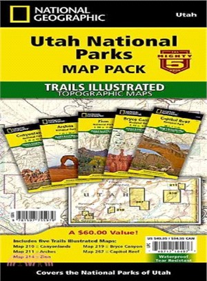
‧ Waterproof ‧ Tear-Resistant ‧ Topographic MapThe five iconic national parks in the high desert of Utah are all provided in this single easy to purchase product. You get the maps for the best road tr
‧ Waterproof ‧ Tear-Resistant ‧ Topographic MapNational Geographic's Trails Illustrated map of Banff South is a two-sided, waterproof map designed to meet the needs of outdoor enthusiasts with unmatch
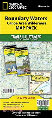
• Waterproof • Tear-Resistant • Topographic MapThe Boundary Waters was recognized for recreational opportunities in 1926, named the Superior Roadless Area in 1938, the BWCA in 1958, and federally desi