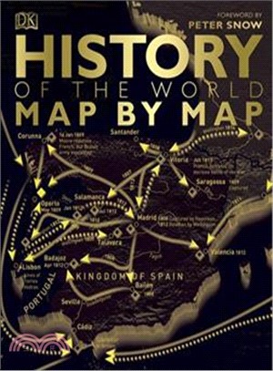
Much more than a history atlas, this ?book drops you right in the heart of the action, as 130 detailed maps tell the story of pivotal episodes in world history, from the first human migrations out of
From monster-slewing heroes to ancient accounts of gods and goddesses from all around the world, such as Thor and Odin, the beautifully illustrated follow-up to Atlas of Monsters and Ghosts is a fun a
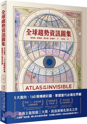
{英國製圖學會獎}{斯坦福斯印刷製圖獎}{約翰・C・巴塞洛繆主題製圖獎}【席捲主題製圖三大獎,資訊視覺化頂尖之作】以細緻「資訊圖」轉化眾多趨勢的數據,呈現難以察覺的人類社會潛藏運作模式!**********幾個世紀以來,地圖描繪了許多具體可見的事物。隨著資訊科技日益強大,如今我們既需要、也有了更進步的「資訊圖」,得以呈現潛藏在資料集當中,形塑人類生活與世界趨勢的重要「模式」。過去十年人們產生的資料,要比在那之前的一百年產生的還多,這些數據能反映出我們本身、我們的生活,乃至我們的世界。然而,隨著這些數據不斷累積,想要去蕪存菁、解讀其深意,從而加以善用,「資料素養」已成為現代人的必修課。資訊圖藉由圖表元素的形狀、顏色、大小、排列、對照等等的應用,能細膩、簡潔又精準地傳達大量數據所蘊含的要點,尤其是這些數據所探查到的「模式」。本書作者一是地理資訊與製圖學教授,一是獲獎連連的設計編輯,兩人長年合作將大數據轉化成精細卻易懂的圖像。他們花費數年精心編纂這本書,滿懷好奇的觸及廣泛議題,以一目瞭然的資訊圖搭配短文,解說龐雜資料背後蘊含的洞見,像是:◎提供救濟,比起異地安置或懲罰更能改善遊民問題;◎了解跨境移動模式,有助於更有效率的救災與因應疾病大流行;◎衛星照片拍到的各地發光狀況,透露出戰爭、經濟發展與城市化等的影響;◎共享單車已成為全球趨勢,但作法需因地制宜;◎厭女症會助長以性別為主的暴力行為;◎船隻的航線不只擾動大海,也會攪動天空、造成更多閃電;◎火災探測衛星的資料顯示,全球暖化導致的西伯利亞火災可能從未完全燒完……全書切入「我們所到之處/我們是誰/我們表現得怎麼樣/我們所面對的事」等面向,說明許多體現當今世界觀的事例,讓讀者在驚艷於精美圖像的同時,吸收關於當今世界的奧祕與概況。(更詳盡的內容可參閱目錄與部分內頁縮圖)【本書特色】◎「主題製圖」多項大獎肯定,所涵蓋議題豐富而多元,圖像表現手法尖端且新穎,既是「藉助資訊圖呈現人類生活重大趨勢」的傑出著述,亦是「資訊圖各種形式如何適用於表達不同資訊」的示範之作,兼具藝術性與知識性,值得珍藏。◎跨領域合作,精選形塑當今重要世界觀的代表性事件,不是用「地圖」單純標示人類活動的「路徑」,而是以「資訊圖」呈現趨勢發展的「模式」,促進讀者對廣泛議題的興趣與了解,幫助培養大局觀與思辨能力。◎繁體中文版尺寸(20.9 x 27.7 x 2.15
榮獲2020年詹姆斯.比爾德獎(James Beard Awards)榮獲2019安德列.西蒙最佳飲品書籍獎(Andre Simon Award Best Drinks Book of 2019)入圍2020路易.侯德爾年度葡萄酒書(Louis Roederer Wine Book of the Year 2020)新舊讀者一致讚譽,英美amazon讀者好評皆4.8星從1971年問世即創立無法超越
DK's outstanding cartography and design combine to create this fifth edition of Compact Atlas of the World, an exceptionally appealing and accessible general atlas in a conveniently sized and budget-f
Head off on a globetrotting adventure in this interactive atlas! Learn about the diverse cultures, customs, wildlife, and natural beauty that form our world through informative text and full-color pho
This beautiful first world atlas will introduce young readers to the planet Earth's different continents and countries and their iconic landmarks species. Appealing art and a sturdy format mean this
This revised edition of DK's groundbreaking 2003 atlas has been refreshed with beautiful, bright, new maps, a topical introductory section, and an interactive CD. Facts, maps, satellite images, and lo
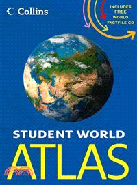
A new and extended edition of a vital tool for students, with new topics including world agriculture, world climate change, low and middle economic developing countries, and?ecological footprint?Altho
Highly detailed maps give balanced worldwide coverage, while beautifully illustrated thematic pages and thousands of facts and statistics enable the user to know the worldPerfect for family reference,
Essential World Atlas, 9th Edition provides an unbeatable visual reference to the world's continents, regions, and countries with more than 90 maps and detailed fact files on every nation.See many dif
Revised and fully up-to-date! A handy, user-friendly atlas at an affordable price, Essential World Atlas is perfect for home, school, and office use. Featuring a series of thematic world maps showing
From the defining boundaries of the Balkan states to the icy terrain of Antarctica, the Concise World Atlas shares more than 400 maps created with the latest digital mapping techniques to bring you Ea


![Gods, Goddesses, and Heroes 1 [AU/UK]](https://cdnec.sanmin.com.tw/product_images/183/183869060.jpg)