

定價
:NT$ 2686 元優惠價
:90 折 2417 元
無庫存,下單後進貨(到貨天數約30-45天)
可得紅利積點:72 點
相關商品
商品簡介
商品簡介
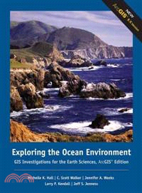
Specifically designed to work in your site-licensed ArcGISR laboratory, the GIS Investigations for the Earth Sciences is a collection of modular investigation guides that let even novice users tap the power of the ArcGISR software to explore, manipulate, and analyze large data sets. Carefully designed and class tested, the guides emphasize the visualization, analysis, and multimedia integration capabilities inherent to GIS. The guide leads students through a set of exercises in which they are asked to explore, analyze, and then elaborate on the information extracted from a robust GIS dataset using your laboratory's ArcGISR software. The GIS information has been preprocessed into maps and legends, and some procedures have been automated so students can focus on the science content. The complete GIS datasets needed to work through each module are available exclusively online and have been designed to be uploaded into the ArcGISR application already installed in your laboratory. By focusing on teaching with GIS rather than teaching about it, you can incorporate GIS easily into homework, discussions, or lab sessions. This flexible teaching resource motivates and enables your students to "learn by doing" as they use a full complement of GIS capabilities. Each module in the GIS Investigations series complements any introductory course in geology, meteorology, oceanography, physical geography, natural hazards, Earth sciences, atmospheric science, and Earth systems science. Specifically designed to work in your site-licensed ArcGISR laboratory, the GIS Investigations for the Earth Sciences is a collection of modular investigation guides that let even novice users tap the power of the ArcGISR software to explore, manipulate, and analyze large data sets. Carefully designed and class tested, the guides emphasize the visualization, analysis, and multimedia integration capabilities inherent to GIS. The guide leads students through a set of exercises in which they are asked to explore, analyze, and then elaborate on the information extracted from a robust GIS dataset using your laboratory's ArcGISR software. The GIS information has been preprocessed into maps and legends, and some procedures have been automated so students can focus on the science content. The complete GIS datasets needed to work through each module are available exclusively online and have been designed to be uploaded into the ArcGISR application already installed in your laboratory. By focusing on teaching with GIS rather than teaching about it, you can incorporate GIS easily into homework, discussions, or lab sessions. This flexible teaching resource motivates and enables your students to "learn by doing" as they use a full complement of GIS capabilities. Each module in the GIS Investigations series complements any introductory course in geology, meteorology, oceanography, physical geography, natural hazards, Earth sciences, atmospheric science, and Earth systems science.


您曾經瀏覽過的商品

購物須知
外文書商品之書封,為出版社提供之樣本。實際出貨商品,以出版社所提供之現有版本為主。部份書籍,因出版社供應狀況特殊,匯率將依實際狀況做調整。
無庫存之商品,在您完成訂單程序之後,將以空運的方式為你下單調貨。為了縮短等待的時間,建議您將外文書與其他商品分開下單,以獲得最快的取貨速度,平均調貨時間為1~2個月。
為了保護您的權益,「三民網路書店」提供會員七日商品鑑賞期(收到商品為起始日)。
若要辦理退貨,請在商品鑑賞期內寄回,且商品必須是全新狀態與完整包裝(商品、附件、發票、隨貨贈品等)否則恕不接受退貨。