

National Geographic Canada West Map ― Travel Maps International Adventure Map
商品資訊
定價
:NT$ 523 元無庫存,下單後進貨(到貨天數約30-45天)
可得紅利積點:15 點
相關商品
商品簡介
商品簡介
‧ Waterproof ‧ Tear-Resistant ‧ Travel Map
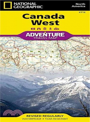
National Geographic's Canada West AdventureMap is designed to meet the needs of adventure travelers with its durability and detailed, accurate information. The map includes the locations of cities and towns with a user-friendly index, a clearly marked road network complete with distances and designations for roads/highways, plus secondary routes for those seeking to explore off the beaten path in and around the Rocky Mountain National Park of Banff, the Yukon Territories, Alberta, Vancouver Island, and the Pacific Shores.
AdventureMaps differ from a traditional road map because of the specialty content they include. Each map contains hundreds of diverse and unique recreational, ecological, cultural, and historic destinations -- outside of the major tourist hubs. Search for whales off the coast of Vancouver, ski the trails of Whistler, paddle the epic South Nahanni River as it tumbles through the jagged Mackenzie Mountains and the Nahanni National Park Reserve, a World Heritage-listed site. National Geographic AdventureMaps are the perfect companion to a guidebook, yet far easier to pack!
Your side one adventure begins at Victoria Island, Nanavut, the Great Slave Lake, the Northwest Territories, Yukon Plateau, Great Bear Lake and Prince Albert Sound. Flip over and the backside showcases the topographic features of Vancouver and Queen Charlotte Islands, the Coast Mountains, British Columbia, the Rocky Mountains, and Alberta.
The Canada West AdventureMap is printed in the United States on a durable synthetic paper, making it waterproof, tear-resistant, and capable of withstanding the rigors of international travel. The map is two-sided and is folded to a packable size of (4.25" x 9.25"); unfolded size is (26" x 38"). Travel Tip! Due to the synthetic sheet that AdventureMaps are printed on, you can easily fold the map to a discreet size, showing just the area you're interested in.
Key Features:
‧ Waterproof and tear-resistant
‧ Designed and printed in the U.S.A.
‧ Detailed topography with clearly labeled natural features
‧ Major road networks
‧ Hundreds of points of interest, including the location of nature reserves and national parks
‧ Thousands of place names with a detailed index
‧ Important travel aids including airports, rail lines, and other infrastructure
‧ Latitude/Longitude and UTM grids along with a compass rose and scale bars for accurate navigation with compass or GPS
- Map Scale = 1:2,100,000
- Sheet Size = 37.75" x 25.5"
- Folded Size = 4.25" x 9.25"


![漂鳥集[中英雙語版]](https://cdnec.sanmin.com.tw/product_images/957/957146403.jpg)


您曾經瀏覽過的商品

購物須知
外文書商品之書封,為出版社提供之樣本。實際出貨商品,以出版社所提供之現有版本為主。部份書籍,因出版社供應狀況特殊,匯率將依實際狀況做調整。
無庫存之商品,在您完成訂單程序之後,將以空運的方式為你下單調貨。為了縮短等待的時間,建議您將外文書與其他商品分開下單,以獲得最快的取貨速度,平均調貨時間為1~2個月。
為了保護您的權益,「三民網路書店」提供會員七日商品鑑賞期(收到商品為起始日)。
若要辦理退貨,請在商品鑑賞期內寄回,且商品必須是全新狀態與完整包裝(商品、附件、發票、隨貨贈品等)否則恕不接受退貨。